As of Tuesday morning, the National Hurricane Center has issued a Hurricane Watch for the west coast of Florida, including Tampa through Tallahassee.
While the Hurricane Watch has been posted before the storm has officially formed, it’s imperative to note that rapid development and rapid intensification is expected in the next 48 hours.
11 am EDT - Tropical Storm #Helene forms. Hurricane and Storm Surge Watches in effect for portions of Florida. Here are the Key Messages. https://t.co/tW4KeGdBFb pic.twitter.com/O2vrmnsReN
— National Hurricane Center (@NHC_Atlantic) September 24, 2024
In fact, landfall of what-is-to-be Hurricane Helene is forecast by Thursday afternoon to early evening.
As of Tuesday morning, the cluster of storms in the Caribbean are still lacking a closed center of circulation, which is why the National Hurricane Center has been reluctant to name this system a tropical storm.
However, the system is forecast to organize quickly through this afternoon, and Tropical Storm “Helene” is expected to form later today.
Track the tropical system using our Interactive Tracker below.
What to Expect in Metro Atlanta
While the exact location of the center of the storm will change over the next 48 to 72 hours, the signal is clear that a good portion of Metro Atlanta will be impacted by damaging winds, heavy rain, and potential tornadoes.
As of Tuesday morning, the time window for Metro Atlanta is late Thursday night through midday Friday.
Damaging Wind Threat
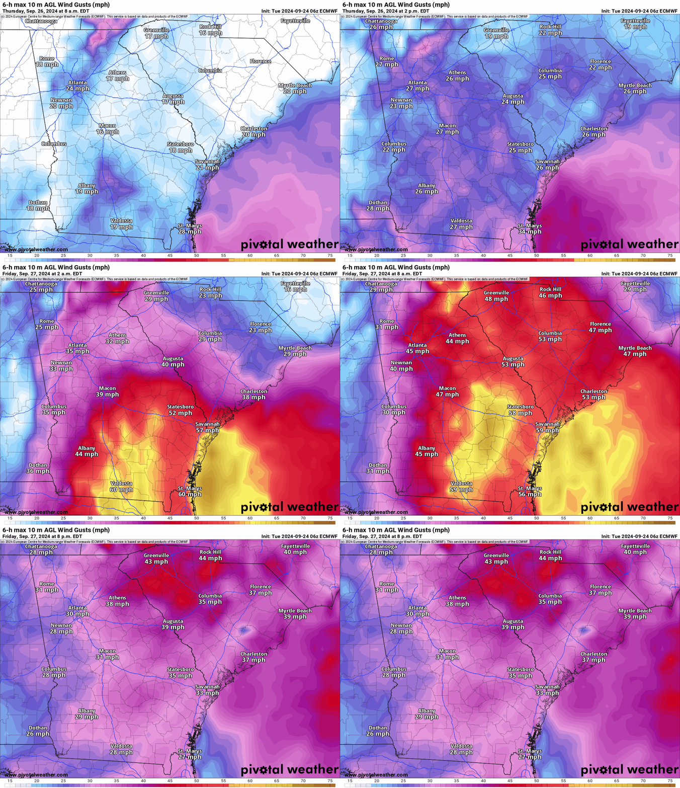
As of Tuesday afternoon, the National Hurricane Center official track plots the center of Helene over Metro Atlanta by 8am Friday morning. Helene is forecast to be a tropical storm by then, with sustained winds as high as 50 mph, and wind gusts as high as 65 mph.
Winds will increase in Metro Atlanta between Thursday night into Friday morning as the rain bands and the core of the storm move north.
Below is the Futurecast Wind Gusts from the Tuesday Morning ECMWF Model.
Monitoring the core of the storm is important: The strongest winds will be to the right of the low, and the threat of quick spin-up tornadoes is highest on the right side of the low.
Potential Rainfall
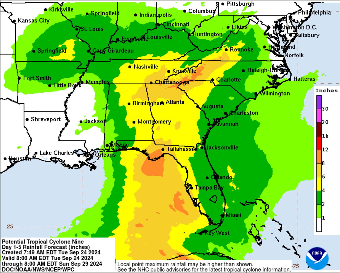
A cold front will bring heavy rainfall to Metro Atlanta on Wednesday, with as much as 1-3 inches of rain possible between Tuesday night and Wednesday night.
As future Helene moves north, an additional 2-3 inches of rainfall is possible between late Thursday night into early Friday morning.
Adding it up, as much as 3-6 inches of rainfall is possible in Metro Atlanta between Tuesday night and Friday morning.
The tropical system will exit north Georgia into Middle Tennessee through the afternoon Friday.
Track the Storm With Me!
Facebook: Christina Edwards WSB
Instagram: ChristinaWSBwx
Twitter: @ChristinaWSBwx
TikTok: @ChristinaEdwards955WSB
©2024 Cox Media Group


